

A walkability score is a 0 to 100 index of how close and how dense the amenities are around an address, calculated mainly from distance to things like grocery stores, restaurants, and schools. The single most important thing to understand: it measures proximity, not quality or safety. A high number means errands are close by. It says nothing about whether the sidewalk to get there actually exists.
TL;DR:
- Walkability scores mainly measure proximity to amenities and do not consider sidewalk quality, safety, or elevation changes that can impact walking experience.
- The score is more reliable for dense, intersected neighborhoods with high amenity overlap, but it can lag behind actual business closures and safety conditions.
- A score of 70 or above generally indicates a walkable area suitable for a car-light or car-free lifestyle, but each address should be verified with walk routes and transit checks.
- The score correlates strongly with neighborhood density but has only a moderate relation to crime levels and does not account for subjective safety or personal priorities.
- Use the score as a filtering tool, then conduct in-person checks, verify transit schedules, and document impressions for a comprehensive evaluation.
Table of Contents
- Understanding Walkability Scores: What They Measure and When to Use Them
- How Walkability Scores Are Calculated: Distance Decay and Pedestrian Adjustments
- Where the Number Falls Short: Blind Spots to Watch For
- What the Research Says About Reliability
- Using a Walkability Score in Your Home Search: A Practical Checklist
- Debugging a Specific Address: A Quick Verification Workflow
- How Much Weight the Score Deserves in Your Decision
- Pairing the Score With a Private Buyer Workflow
- Keep Your Walkability Notes and Comparisons in One Place
- Where to Verify the Numbers Yourself
- Sources
Understanding Walkability Scores: What They Measure and When to Use Them
The 0 to 100 scale breaks into five labeled bands, and knowing them saves you from misreading a number out of context. A 90 to 100 score is a "Walker's Paradise," meaning daily errands don't require a car at all. Scores from 70 to 89 fall under "Very Walkable," 50 to 69 is "Somewhat Walkable," 25 to 49 means most errands require driving, and anything under 25 is essentially car-dependent territory, as explained in this luxury buyer's guide to walkable coastal communities.
The index counts amenities across roughly a dozen categories, spanning grocery stores, restaurants, schools, parks, coffee shops, banks, and retail. Real estate listings lean on this number for a few practical reasons:
- Quickly screening dozens of listings before scheduling in-person tours
- Comparing two rental units in different neighborhoods at a glance
- Estimating whether a car-light or car-free lifestyle is realistic at a given address
- Flagging areas worth a closer look for transit-dependent renters
None of that replaces walking the block yourself, but as a first filter, it's efficient.
How Walkability Scores Are Calculated: Distance Decay and Pedestrian Adjustments
The math behind the number is more specific than most people assume, and understanding it helps you judge whether a given score is trustworthy for your situation.
- Distance decay determines point value. An amenity within about 0.25 miles, roughly a five-minute walk, earns full points. That value shrinks the farther away it sits, hitting zero once you pass roughly 1.5 miles, or about a 30-minute walk, according to Walk Score's own methodology.
- Multiple amenities in a category stack, with diminishing returns. A neighborhood with three grocery stores within a mile scores higher on that category than one with a single store, though the closest one dominates the calculation.
- Categories are weighted roughly equally. Restaurants, schools, parks, and grocery stores each contribute to the total, which means an area stacked with cafes can score similarly to one with genuinely different amenities like a full grocery store or a pharmacy.
- Pedestrian-friendliness adjusts the raw number. Intersection density, average block length, and population density all factor in, since a grid of short blocks with frequent crossings is more walkable in practice than the same amenities spread along a single long arterial road.
- The underlying map data comes from multiple sources. Walk Score pulls from Google, OpenStreetMap, the U.S. Census, and community-submitted listings, which keeps things current but can still lag behind a business that closed last month.
Where the Number Falls Short: Blind Spots to Watch For
The score is a proximity calculation, not a lived-experience rating, and several things that matter to actual walking are simply outside its scope.
- It doesn't check whether a sidewalk exists at all, let alone whether it's cracked, unlit, or missing a curb cut.
- Crosswalk safety and lighting after dark aren't part of the formula.
- Hills and steep grades go uncounted, so two addresses with identical amenity proximity can feel completely different on foot if one requires a serious climb.
- Crime and perceived safety are excluded entirely from the computation.
- Amenity relevance isn't personalized. A cluster of bars and coffee shops boosts the score the same way a grocery store and a pharmacy would, even though a family with young kids weighs those very differently.
Pro Tip: Pull up the address on Walk Score and check which specific businesses are driving the number. If the top contributors are three coffee shops and a nail salon, that "82" means something very different than if it's anchored by a grocery store, a pharmacy, and an elementary school.
What the Research Says About Reliability
Academic scrutiny of the algorithm gives it a mixed but useful report card. A peer-reviewed evaluation of nearly 300 addresses found Walk Score correlates strongly with intersection density (0.81) and residential density (0.76), with a moderate correlation to transit access (0.52). That's a solid validation of the core premise: denser, more intersected neighborhoods really do score higher, and the number tracks something real about urban form.
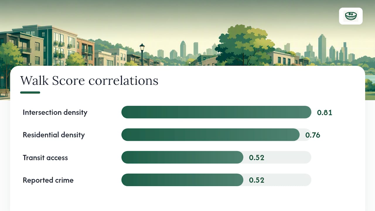
The same study found a correlation of roughly 0.52 between Walk Score and reported crime. That doesn't mean walkable neighborhoods cause crime. It means dense, amenity-rich areas sometimes coincide with higher crime reporting, and the score can't distinguish a lively, safe corridor from one that isn't. The EPA's National Walkability Index takes a different approach entirely, ranking Census block groups nationwide for planning and policy purposes rather than scoring individual addresses for consumers, so the two tools serve different audiences even when people expect them to agree.

Using a Walkability Score in Your Home Search: A Practical Checklist
Treat the score as a starting filter, not a final answer, and work through it in this order.
- Set a threshold that matches your lifestyle. If you want to ditch a car entirely, filter for 70 and above. If you're fine driving to the grocery store but want a walkable dog loop and a nearby coffee shop, 50 to 69 might suit you fine.
- Open the amenity breakdown for any address you're serious about. Confirm the categories driving the score actually match your priorities, whether that's transit, schools, or a full-service grocery store.
- Walk the actual route at two different times of day. Morning commute traffic and evening lighting reveal things a static number never will.
- Check transit schedules directly, since a bus stop two blocks away is worthless if it runs once an hour.
- Log your impressions somewhere organized the moment you leave, rather than trusting memory across a dozen tours. A private research tool built for this keeps sidewalk notes, safety impressions, and score data attached to the same listing instead of scattered across texts and screenshots.
Debugging a Specific Address: A Quick Verification Workflow
Before trusting a number for a specific listing, run a few quick checks that take fifteen minutes and catch most of the algorithm's blind spots.
- Map the actual walking route in Google Maps or a similar tool, not just straight-line distance, to spot missing sidewalks or a highway you'd have to cross.
- Look up real transit schedules for the nearest stop rather than assuming frequency matches proximity.
- Call or check hours for the specific businesses driving the score. Data lags reality, and a closed restaurant still counts toward the total until the listing updates.
- Run the address through an elevation tool like Google Earth to catch grades that a flat map hides completely.
This kind of neighborhood-level documentation matters more than most buyers realize, especially when comparing several addresses that all score in the same range.
How Much Weight the Score Deserves in Your Decision
A walkability score deserves a supporting role, not a deciding vote. Use it first to filter listings down to a manageable shortlist. Then verify with an actual walking route, transit schedules, and a visit at more than one time of day. Finally, write down what you noticed while it's fresh, because a sidewalk that felt unsafe at dusk won't show up in any algorithm.
Pairing the Score With a Private Buyer Workflow
A number alone doesn't make a decision for you, and treating it like a final grade is where a lot of buyers go wrong. The more useful approach pairs the objective score with structured, private notes gathered on each tour: what the walk to the coffee shop actually felt like, whether the crosswalk near the school had a working signal, whether the "nearby" grocery store turned out to be a fifteen-minute uphill walk.
Buyers comparing five or six addresses tend to remember the first one clearly and blur the rest together by the third weekend of touring. A side-by-side comparison that holds both the score and your own impressions in one place solves that problem directly.
— Antony
Keep Your Walkability Notes and Comparisons in One Place
Comparing walkability scores across a dozen listings gets messy fast when the details live in browser tabs, texts to your agent, and half-remembered impressions from a tour three weekends ago. Nestnoted gives serious buyers a private place to log exactly that: pull in a listing from Zillow or Redfin, attach your notes on the walk to the coffee shop or the crosswalk that gave you pause, and compare it side-by-side against the next three addresses on your list.

Everything stays private by default, so you can write down that the "very walkable" score didn't account for the steep hill without worrying about it showing up anywhere public. If you're touring properties this month and want your walkability research organized instead of scattered, start a free workspace at Nestnoted and log your first address today.
Where to Verify the Numbers Yourself
For readers who want to check the calculation directly rather than take any explainer's word for it, three sources cover the ground this article draws from. The Walk Score Methodology page lays out the distance-decay formula and data sources in full. The EPA's National Walkability Index user guide explains the government's separate, planning-focused ranking system. And the peer-reviewed validation study in the research literature is the one to read for the correlation data behind the reliability claims above.
Sources
- Walk Score Methodology
- Walk Score™ As a Global Estimate of Neighborhood Walkability (peer-reviewed article)
- National Walkability Index User Guide and Methodology